Near the end of the war, many Union fortifications and batteries were constructed around the perimeter of Louisville to protect Kentucky's largest city from invasion. None of the many forts constructed at Louisville have survived, but visiting the following locations can allow one to visualize the strategy used by Federal forces to protect Louisville from Confederate invasion. All forts in Louisville were named for officers killed in battle.
Fort Elster: Between Frankfort Ave. and Brownsboro Rd. in the vicinity of Bellaire, Vernon, and Emerald Aves.
Fort Engle: Near Spring St. and Arlington Ave.
Fort Saunders: In Cave Hill Cemetery
Fort Hill: Between Goddard Avenue and St. Louis Cemetery
Fort Horton: At the junction of Shelby and Merriwether Sts.
Fort McPherson (the largest fortification): Preston St. area, bounded by Barbee, Brandies, Hahn and Fort Sts.;
Fort Philpot: Seventh St. Rd. and Algonquin Parkway
Fort Saint Clair Morton: 16th and Hill Sts.
Fort Karnash: On Wilson Ave. between 26th and 28th Sts.
Fort Clark: At 36th and Magnolia Sts.
Fort Southworth: On Paddy's Run
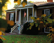
FARMINGTON: Plantation life from 1812 through the Civil War is interpreted at this historic home that was designed by Thomas Jefferson. The changing roles of the African-Americans who lived on this farm owned by Joshua Fry Speed, a close friend of Abraham Lincoln, are highlighted. A guided tour features octagonal rooms, a hidden stairway, blacksmith shop and a 19th-century garden ($4, M-Sat 10-4:30, Sun 1:30-4:30, last tour 3:45, 3033 Bardstown Road, 502/452-9920, handicapped accessible).
CAVE HILL CEMETERY : Both Confederate and Union troops are interred at this beautiful National Cemetery, which features several commemorative monuments. 701 Baxter Ave.
The Filson Club Historical Society, located in Old Louisville's 1900 Ferguson Mansion, 1310 S Third, has an exceptional genealogy library ($3) and manuscript, photography and museum collections (free). The society recently acquired the papers of Major General Don Carlos Buell, who lost his command after his army failed to crush Confederate forces at the Battle of Perryville in 1862. The historical society was founded in 1884 and named for Kentucky's first historian, John Filson (M-F 9-5, 502/635-5083, handicapped accessible).
In 1860 the Industrial School of Reform and House of Refuge was founded at 2301 South Third Street, but was taken over by Federal troops and used as a barracks and parade ground. Now called Belknap Campus, this institution is part of the University of Louisville.
The Taylor Barracks at Third and Oak Streets served as an induction center for African-American recruits. At 641 Baxter Avenue is Eastern Cemetery where many of these soldiers were interred.
The Public Library and Museum at Fifth and York Streets originally served as the Fifth Ward School. The building was used by the Union army as a military hospital during the war.
CIVIL WAR HISTORICAL MARKERS IN AND NEAR LOUISVILLE:
Farmington (State Marker 174, Jct. Bardstown Rd. & Wendell St. US 31E. Louisville)
Belknap Campus (State Marker 541, University of Louisville campus, Louisville)
Artist of Confederacy (State Marker 681, Cave Hill Cemetery, US 60 & 460, Louisville)
Perryville Prelude (State Marker 548, west of Middletown, US 60 & 460, Jefferson Co.)
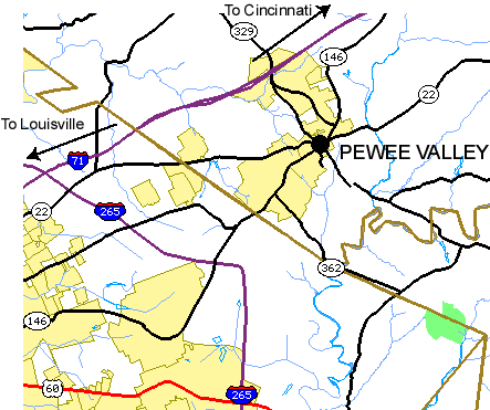
CSA Cemetery (State Marker 182, Maple Ave., Pewee Valley, KY
146)
Just outside of Louisville is the PeWee Valley Confederate Cemetery. This cemetery for the Kentucky Confederate Home was established in 1904 for Confederate veterans. Over 300 veterans, mostly residents of the Home, now lay in the cemetery. South side of Maple Ave. south of Old Floydsburg Rd., PeWee Valley, KY.