Streams of the Western Coalfields -
Tradewater River KY 70 to Ohio River

Maps and info from A Canoeing and Kayaking Guide to the Streams of Kentucky by Bob Sehlinger (used by permission).

Tradewater River KY 70 to Ohio River Map

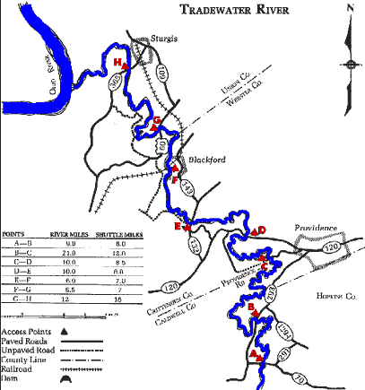
COUNTIES: Hopkins, Webster, Union

USGS QUADS: Dawson Springs, Olney, Dalton, Providence, Blackford, Sturgis, Dekoven

LEVEL OF DIFFICULTY: International class I     Numerical points 5

SUITABLE FOR: Cruising, camping (at low water levels)

GRADIENT (feet per mile): 0.70

APPROPRIATE FOR: Families, Beginners, Intermediates, Advanced

VELOCITY (mph): 0-2.5

AVERAGE WIDTH (ft): 30-65

MONTHS RUNNABLE: All (except possibly late summer and early fall)

MEAN WATER TEMPERATURE (ºF):

JAN  41 FEB  42 MAR  49 APR  54 MAY  65 JUN  75
JUL  77 AUG  75 SEP 69 OCT 60 NOV 49 DEC 41

SOURCE OF ADDITIONAL INFORMATION ON WATER CONDITIONS:

Providence Police Dept. (270) 667-2022

HAZARDS: Deadfalls, low trees

RESCUE INDEX: C

PORTAGES: Around deadfalls and extremely low water at times

SCOUTING: None required

INTEREST HIGHLIGHTS: Scenery, local culture and industry

SCENERY: Uninspiring to pretty in spots

ACCESS POINT AND CODE:

A 1 3 6 8
B 1 3 6 8
C 1 3 6 8
D 1 3 6 8
E 1 3 6 7
F 1 3 6 7
G 1 4 6 8
H 1 3 6 7
KEY

Rescue Index

Access Code

K Extremely remote; evacuation only with expert help--6 hours to secure assistance 1 Paved Road
2 Unpaved Road
3 Short Carry
L Remote; 3-6 hours to secure assistance 4 Long Carry
5 Easy Grade
6 Steep Grade
M Accessible but difficult; up to 3 hours to secure assistance-- evacuation difficult 7 Clear Trail
8 Brush and Trees
9 Private Property, Permission needed
N Accessible; up to 1 hour to secure assitance, evacuation not difficult 10 Launching Fee Charged
11 No Access--Reference Only

WMTH CORPORATION PO BOX 51153 BOWLING GREEN, KY 42102 PHONE (270) 792-5300 FAX 721-0004