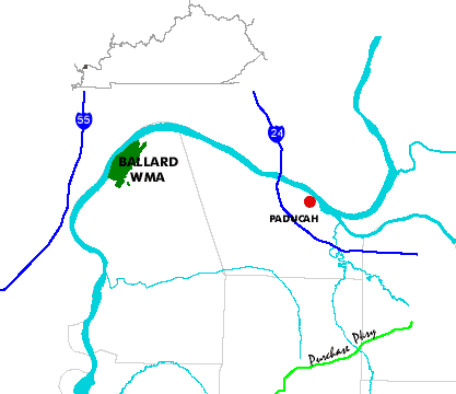
Ballard WMA Region Map

Ballard WMA is one of the most unusual water resources in the state of Kentucky.  Consisting of more tha fifteen oxbow lakes and cypress bogs, the refuge/hunting area is home to countless deer, beaver, waterfowl, songbirds, and reptiles.  Captivating in its primeval beauty, sometimes ghostly and mysterious with imposing cypress standing guard over a water carpet of lotus, this area is always alive, always alluring.  For the paddler whose canoe allows exploring without restriction, the lakes of the Ballard WMA offer unparalleled serenity and an opportunity to observe firsthand myriad forms of bird, animal, and fish life. 

Several well-kept primitive camping areas designated within the WMA serve as base camps from which the refuge can be explored.   Lakes and bogs are generally separated by only a few hundred feet so that portaging from one lake to another is not difficult.  There are no hazards to navigation--insects and mosquitoes represent the only potential nuisance.

Maps and info from A Canoeing and Kayaking Guide to the Streams of Kentucky by Bob Sehlinger (used by permission).

Canoeing in Ballard Wildlife Management Area Map

COUNTIES: Ballard

USGS QUADS: Olmstead, Barlow

LEVEL OF DIFFICULTY: International class N/A     Numerical points N/A

SUITABLE FOR: Cruising

GRADIENT (feet per mile): 0

APPROPRIATE FOR: Families, Beginners, Intermediates, Advanced

VELOCITY (mph): Lakes

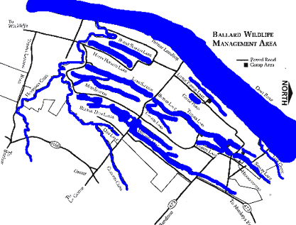
AVERAGE WIDTH (ft): 200-900

MONTHS RUNNABLE: March 15 to October 15

MEAN WATER TEMPERATURE (ºF): Data not available

SOURCE OF ADDITIONAL INFORMATION ON WATER CONDITIONS:

Ballard WMA (270) 224-2244

HAZARDS: None

RESCUE INDEX: D

PORTAGES: None required

SCOUTING: None required

INTEREST HIGHLIGHTS: Scenery, history, wildlife

SCENERY: Beautiful to exceptionally beautiful

ACCESS POINT AND C

ODE:

ALL 2 3 5 7
KEY

Rescue Index

Access Code

K Extremely remote; evacuation only with expert help--6 hours to secure assistance 1 Paved Road
2 Unpaved Road
3 Short Carry
L Remote; 3-6 hours to secure assistance 4 Long Carry
5 Easy Grade
6 Steep Grade
M Accessible but difficult; up to 3 hours to secure assistance-- evacuation difficult 7 Clear Trail
8 Brush and Trees
9 Private Property, Permission needed
N Accessible; up to 1 hour to secure assitance, evacuation not difficult 10 Launching Fee Charged
11 No Access--Reference Only

WMTH CORPORATION PO BOX 51153 BOWLING GREEN, KY 42102 PHONE (270) 792-5300 FAX 721-0004