Streams of the Western Coalfields -
Rough River Dundee to Green River

Maps and info from A Canoeing and Kayaking Guide to the Streams of Kentucky by Bob Sehlinger (used by permission).

Rough River Dundee to Green River Map

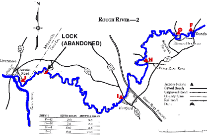
COUNTIES: Ohio, McLean

USGS QUADS: Dundee, Horton, Hartford, Equality

LEVEL OF DIFFICULTY: International class I     Numerical points 5

SUITABLE FOR: Cruising

GRADIENT (feet per mile): 0.6

APPROPRIATE FOR: Beginners, Intermediates, Advanced

VELOCITY (mph): 0-5.0

AVERAGE WIDTH (ft): 55-70

MONTHS RUNNABLE: All

MEAN WATER TEMPERATURE (ºF):

JAN  42 FEB  43 MAR  48 APR  54 MAY  65 JUN  74
JUL  76 AUG  75 SEP 68 OCT 59 NOV 45 DEC 41

SOURCE OF ADDITIONAL INFORMATION ON WATER CONDITIONS:

Corps of Engineers (270) 257-2061

HAZARDS: Dams, deadfalls

RESCUE INDEX: C

PORTAGES: Abandoned lock upstream from Livermore

SCOUTING: None required

INTEREST HIGHLIGHTS: Scenery, local culture and industry

SCENERY: Pleasant to pretty in spots

ACCESS POINT AND CODE:

F 2 3 6 8
G 2 3 6 8
H 2 3 6 7
I 2 3 6 7
J 1 3 6 8
KEY

Rescue Index

Access Code

K Extremely remote; evacuation only with expert help--6 hours to secure assistance 1 Paved Road
2 Unpaved Road
3 Short Carry
L Remote; 3-6 hours to secure assistance 4 Long Carry
5 Easy Grade
6 Steep Grade
M Accessible but difficult; up to 3 hours to secure assistance-- evacuation difficult 7 Clear Trail
8 Brush and Trees
9 Private Property, Permission needed
N Accessible; up to 1 hour to secure assitance, evacuation not difficult 10 Launching Fee Charged
11 No Access--Reference Only

WMTH CORPORATION PO BOX 51153 BOWLING GREEN, KY 42102 PHONE (270) 792-5300 FAX 721-0004