Salt River System -
Salt River Shepherdsville to the Ohio River

Maps and info from A Canoeing and Kayaking Guide to the Streams of Kentucky by Bob Sehlinger (used by permission).

sltshepmap1.gif (11476 bytes)

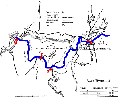
COUNTIES: Bullitt, Hardin

USGS QUADS: Shepherdsville, Pitts Point, Fort Knox, Kosmosdale

LEVEL OF DIFFICULTY: International class I     Numerical points 5

SUITABLE FOR: Cruising

GRADIENT (feet per mile): 1.66

APPROPRIATE FOR: Families, Beginners, Intermediates, Advanced

VELOCITY (mph): 0-2.5

AVERAGE WIDTH (ft): 60-90

MONTHS RUNNABLE: All

MEAN WATER TEMPERATURE (ºF):

JAN  42 FEB  42 MAR  45 APR  54 MAY  68 JUN  76
JUL  78 AUG  78 SEP 69 OCT 61 NOV 46 DEC 43

SOURCE OF ADDITIONAL INFORMATION ON WATER CONDITIONS:

Corps of engineers (502) 477-8606

HAZARDS: Deadfalls, Fort Knox Artillery Range

RESCUE INDEX: B-C

PORTAGES: None Required

SCOUTING: None Required

INTEREST HIGHLIGHTS: Scenery, local culture and industry

SCENERY: Pleasant to pretty in spots

ACCESS POINT AND CODE:

R 2 3 6 7

S

(11)
T 2 3 6 8
U 2 3 6 8
KEY

Rescue Index

Access Code

K Extremely remote; evacuation only with expert help--6 hours to secure assistance 1 Paved Road
2 Unpaved Road
3 Short Carry
L Remote; 3-6 hours to secure assistance 4 Long Carry
5 Easy Grade
6 Steep Grade
M Accessible but difficult; up to 3 hours to secure assistance-- evacuation difficult 7 Clear Trail
8 Brush and Trees
9 Private Property, Permission needed
N Accessible; up to 1 hour to secure assitance, evacuation not difficult 10 Launching Fee Charged
11 No Access--Reference Only

WMTH CORPORATION PO BOX 51153 BOWLING GREEN, KY 42102 PHONE (270) 792-5300 FAX 721-0004