Salt River System -
Plum Creek Wilsonville to Salt River

Maps and info from A Canoeing and Kayaking Guide to the Streams of Kentucky by Bob Sehlinger (used by permission).

Plum Creek Map

COUNTIES: Spencer

USGS QUADS: Fisherville, Waterford

LEVEL OF DIFFICULTY: International class II(III)     Numerical points 14

SUITABLE FOR: Cruising

GRADIENT (feet per mile): 25.7

APPROPRIATE FOR: Intermediates, Advanced

VELOCITY (mph): 5.0+

AVERAGE WIDTH (ft): 35-60

MONTHS RUNNABLE: Early spring and after heavy rains

MEAN WATER TEMPERATURE (ºF):

JAN  41 FEB  42 MAR  44 APR  51 MAY  66 JUN  76
JUL  78 AUG  76 SEP 66 OCT 60 NOV 45 DEC 42

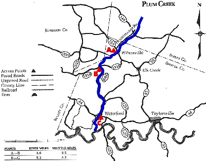
SOURCE OF ADDITIONAL INFORMATION ON WATER CONDITIONS:

Spencer Co. Sheriff Dept. (502)477-5533

HAZARDS: Dams, low bridges, fences, keeper hydraulics, difficult rapids, scarcity of eddy

RESCUE INDEX: D

PORTAGES: Low water bridge and barbed-wire fence one-third mile below KY 155

SCOUTING: Section along KY 1060 from road

INTEREST HIGHLIGHTS: Whitewater

SCENERY: Pretty in spots

ACCESS POINT AND CODE:

A 1 3 5 7
B 1 3 5 7
C 1 3 5 7
KEY

Rescue Index

Access Code

K Extremely remote; evacuation only with expert help--6 hours to secure assistance 1 Paved Road
2 Unpaved Road
3 Short Carry
L Remote; 3-6 hours to secure assistance 4 Long Carry
5 Easy Grade
6 Steep Grade
M Accessible but difficult; up to 3 hours to secure assistance-- evacuation difficult 7 Clear Trail
8 Brush and Trees
9 Private Property, Permission needed
N Accessible; up to 1 hour to secure assitance, evacuation not difficult 10 Launching Fee Charged
11 No Access--Reference Only

WMTH CORPORATION PO BOX 51153 BOWLING GREEN, KY 42102 PHONE (270) 792-5300 FAX 721-0004