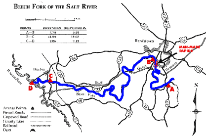
Salt River System -
Beech Fork to Rolling Fork

Maps and info from A Canoeing and Kayaking Guide to the Streams of Kentucky by Bob Sehlinger (used by permission).

Beech Fork KY 49 to Rolling Fork Map

COUNTIES: Nelson

USGS QUADS: Bardstown, Cravens, Lebanon Junction

LEVEL OF DIFFICULTY: International class   I (One man-made Class III, 7 points--advanced paddlers only     Numerical points 4

SUITABLE FOR: Cruising

GRADIENT (feet per mile): 1.43

APPROPRIATE FOR: Beginners, Intermediates, Advanced

VELOCITY (mph): 2.6-5.0

AVERAGE WIDTH (ft): 30-70

MONTHS RUNNABLE: November to early June

MEAN WATER TEMPERATURE (ºF):

JAN  42 FEB  43 MAR  46 APR  54 MAY  66 JUN  76
JUL  77 AUG  77 SEP 65 OCT 60 NOV 45 DEC 43

SOURCE OF ADDITIONAL INFORMATION ON WATER CONDITIONS:

None available

HAZARDS: Deadfalls, low trees, man-made rapid

RESCUE INDEX: C

PORTAGES: At man-made rapid at low water levels

SCOUTING: Man-made rapid   mil mile above US 31E bridge

INTEREST HIGHLIGHTS: Scenery, history, local culture and industry

SCENERY: Pleasant to pretty in spots

ACCESS POINT AND CODE

A 1 3 6 8
B 1 3 6 7
C 1 3 6 8
D 1 4 6 8
KEY

Rescue Index

Access Code

K Extremely remote; evacuation only with expert help--6 hours to secure assistance 1 Paved Road
2 Unpaved Road
3 Short Carry
L Remote; 3-6 hours to secure assistance 4 Long Carry
5 Easy Grade
6 Steep Grade
M Accessible but difficult; up to 3 hours to secure assistance-- evacuation difficult 7 Clear Trail
8 Brush and Trees
9 Private Property, Permission needed
N Accessible; up to 1 hour to secure assitance, evacuation not difficult 10 Launching Fee Charged
11 No Access--Reference Only

WMTH CORPORATION PO BOX 51153 BOWLING GREEN, KY 42102 PHONE (270) 792-5300 FAX 721-0004