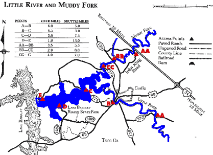
Streams of Land Between the Lakes -
Little River KY 272 to Lake Barkley

Maps and info from A Canoeing and Kayaking Guide to the Streams of Kentucky by Bob Sehlinger (used by permission).

Little River and Muddy Fork Map

COUNTIES: Trigg

USGS QUADS: Roaring Spring, Caledonia, Cadiz, Cobb, Lamasco, Canton

LEVEL OF DIFFICULTY: International class I+     Numerical points 7

SUITABLE FOR: Cruising, camping

GRADIENT (feet per mile): 0.98

APPROPRIATE FOR: Families, Beginners, Intermediates, Advanced

VELOCITY (mph): 0-5.0

AVERAGE WIDTH (ft): 55-70

MONTHS RUNNABLE: November to mid-July (KY 272 to Cadiz); all (Cadiz to Lake Barkley)

MEAN WATER TEMPERATURE (ºF):

JAN  46 FEB  46 MAR  47 APR  54 MAY  64 JUN  73
JUL  74 AUG  74 SEP 71 OCT 62 NOV 54 DEC 44

SOURCE OF ADDITIONAL INFORMATION ON WATER CONDITIONS:

Caidz Police Dept. (270) 522-3305

HAZARDS: Dams, deadfalls, powerboats below Cadiz

RESCUE INDEX: C

PORTAGES: Deadfalls and small dam 1 mile below KY 272 bridge

SCOUTING: None required

INTEREST HIGHLIGHTS: Scenery

SCENERY: Pretty to beautiful in spots

ACCESS POINT AND CODE:

A 1 3 6 7
B 1 3 5 7
C 1 3 5 7
D 1 3 5 7
E 1 3 5 7
KEY

Rescue Index

Access Code

K Extremely remote; evacuation only with expert help--6 hours to secure assistance 1 Paved Road
2 Unpaved Road
3 Short Carry
L Remote; 3-6 hours to secure assistance 4 Long Carry
5 Easy Grade
6 Steep Grade
M Accessible but difficult; up to 3 hours to secure assistance-- evacuation difficult 7 Clear Trail
8 Brush and Trees
9 Private Property, Permission needed
N Accessible; up to 1 hour to secure assitance, evacuation not difficult 10 Launching Fee Charged
11 No Access--Reference Only

WMTH CORPORATION PO BOX 51153 BOWLING GREEN, KY 42102 PHONE (270) 792-5300 FAX 721-0004