Stream of the Jackson Purchase -
Obion Creek US 51 to Mouth

Maps and info from A Canoeing and Kayaking Guide to the Streams of Kentucky by Bob Sehlinger (used by permission).

Obion Creek US 51 to Mouth Map

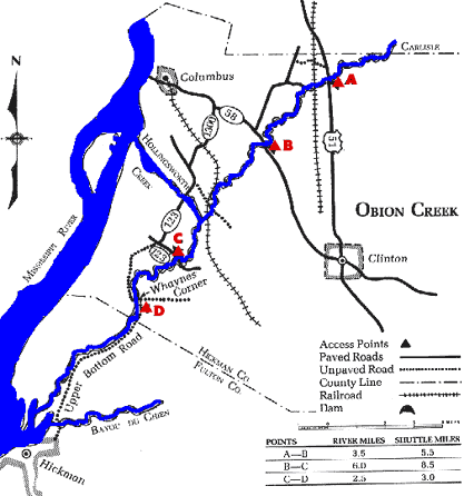
COUNTIES: Hickman, Fulton

USGS QUADS: Oakton, Wolf Island, Hickman

LEVEL OF DIFFICULTY: International class I     Numerical points 7

SUITABLE FOR: Cruising

GRADIENT (feet per mile): 2.48

APPROPRIATE FOR: Intermediates, Advanced

VELOCITY (mph): 0-2.5

AVERAGE WIDTH (ft): 25-40

MONTHS RUNNABLE: November to mid-June

MEAN WATER TEMPERATURE (ºF):

JAN  45 FEB  43 MAR  47 APR  57 MAY  66 JUN  75
JUL  77 AUG  76 SEP 73 OCT 61 NOV 52 DEC 45

SOURCE OF ADDITIONAL INFORMATION ON WATER CONDITIONS:

Hickman Police Dept. (270) 236-2529

HAZARDS: Deadfalls, low trees, flash floods

RESCUE INDEX: C

PORTAGES: Countless logjams and deadfalls

SCOUTING: None required

INTEREST HIGHLIGHTS: Wildlife

SCENERY: Uninspiring

ACCESS POINT AND CODE:

A 1 3 6 8
B 1 3 6 8
C 1 3 6 8
D 2 3 6 8
KEY

Rescue Index

Access Code

K Extremely remote; evacuation only with expert help--6 hours to secure assistance 1 Paved Road
2 Unpaved Road
3 Short Carry
L Remote; 3-6 hours to secure assistance 4 Long Carry
5 Easy Grade
6 Steep Grade
M Accessible but difficult; up to 3 hours to secure assistance-- evacuation difficult 7 Clear Trail
8 Brush and Trees
9 Private Property, Permission needed
N Accessible; up to 1 hour to secure assitance, evacuation not difficult 10 Launching Fee Charged
11 No Access--Reference Only

WMTH CORPORATION PO BOX 51153 BOWLING GREEN, KY 42102 PHONE (270) 792-5300 FAX 721-0004