Green River Bend Road Boat Ramp to KY 88 Bridge

Maps and info from A Canoeing and Kayaking Guide to the Streams of Kentucky by Bob Sehlinger (used by permission).

Green River Bend Rd. Boat Ramp to KY 88 Bridge Map

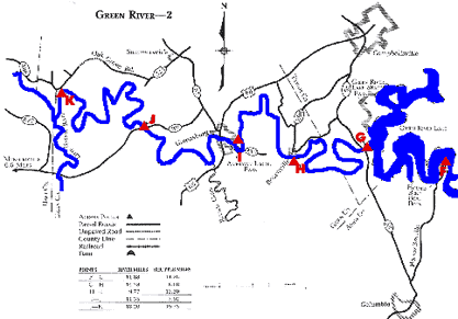
COUNTIES: Adair, Taylor, Green

USGS QUADS: Knifley, Cane Valley, Gresham, Breensburg, Summersville, Hudgins

LEVEL OF DIFFICULTY: International class I+     Numerical points 6

SUITABLE FOR: Cruising, camping

GRADIENT (feet per mile): 1.01

APPROPRIATE FOR: Families, Beginners, Intermediates, Advanced

VELOCITY (mph): 2.6-5.0

AVERAGE WIDTH (ft): 55-80

MONTHS RUNNABLE: All when dam is releasing

MEAN WATER TEMPERATURE (ºF):

JAN  45 FEB  45 MAR  48 APR  54 MAY  65 JUN  72
JUL  74 AUG  74 SEP 67 OCT 58 NOV 47 DEC 43

SOURCE OF ADDITIONAL INFORMATION ON WATER CONDITIONS:

Corps of Engineers (270) 465-4463

HAZARDS: Deadfalls

RESCUE INDEX: C-D

PORTAGES: Green River Dam

SCOUTING: None required

INTEREST HIGHLIGHTS: Scenery, wildlife

SCENERY: Pretty to beautiful in spots

ACCESS POINT AND CODE:

F 1 3 5 7

G

1 3 5 7
H 2 3 5 7
I 1 3 5 7
J 1 3 6 8
K (11)
KEY

Rescue Index

Access Code

K Extremely remote; evacuation only with expert help--6 hours to secure assistance 1 Paved Road
2 Unpaved Road
3 Short Carry
L Remote; 3-6 hours to secure assistance 4 Long Carry
5 Easy Grade
6 Steep Grade
M Accessible but difficult; up to 3 hours to secure assistance-- evacuation difficult 7 Clear Trail
8 Brush and Trees
9 Private Property, Permission needed
N Accessible; up to 1 hour to secure assitance, evacuation not difficult 10 Launching Fee Charged
11 No Access--Reference Only

WMTH CORPORATION PO BOX 51153 BOWLING GREEN, KY 42102 PHONE (270) 792-5300 FAX 721-0004