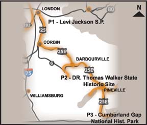
P1 – Levi Jackson Wilderness Road State Park
(606) 878-8000 From Cumberland Falls SRP take KY 90 E to I 75 N. Travel approximately 10 miles and turn right on KY 192, then right on KY 229 and travel 3 miles. *Lodging, dining, and gas opportunities in nearby London, KY.
Levi Jackson Wilderness Road State Park honors both the first judge in Laurel County, and the road that has been termed by some to be the most significant trail in the westward flow of English colonization. The park encompasses over 800 acres and includes the Defeated Camp Pioneer Burial Ground, McHargue's Mill, and the Mountain Life Museum. The Wilderness Road and Boone's Trace, both thoroughfares for many a pioneer coming from the East, pass through the park.
Habitat and Trail info: Between 1774 and 1796, more than 200,000 pioneers traveled over the Wilderness Road and Boone's Trace during the settlement of Kentucky. Today, visitors to the park can retrace the footsteps of the early pioneers on eight-and-one-half miles of hiking trails that include original portions of these historic throughways.
Wildlife Viewing Opportunities: Woodland songbirds including wood thrush, ovenbird, scarlet tanager, and red-eyed vireo. Upland game birds include wild turkey and ruffed grouse. Gray squirrels, opossums, skunks, are abundant. Coyotes and bobcats are sometimes encountered.
P2 – Dr. Thomas Walker State Historic Site
(606) 546-4400 From Corbin continue South on US –25E to Barbourville, KY. Dr. Thomas Walker State Historic Site is located five miles southwest of Barbourville on KY 459. Turn right onto 459. Gas, lodging, and dining opportunities available in nearby Barbourville, KY.
Although Daniel Boone is remembered in legend, Dr. Thomas Walker in fact preceded Boone by 17 years into Kentucky. A physician and surveyor, he led the first expedition through Cumberland Gap in 1750. Near the river, which he named the Cumberland, Walker built a cabin, a replica of which stands on the site today.
Tours: The house and surrounding grounds can be toured free of charge year-round.
Wildlife Viewing Opportunities: This site is of historical significance only. Wildlife viewing opportunities can be accessed at nearby Barbourville, KY. At the Union College Turner Outdoor Center.
P3 - Cumberland Gap National Historical Park
(606) 248-2817 Cumberland Gap National Historic Park is located near Middlesboro, KY on US 25. From I 75 take exit 29 at Corbin. Follow US 25 E south through Pineville and Middlesboro. Gas, lodging, and dining opportunities available in nearby Middlesboro, KY.
Carved by wind and water, the Cumberland Gap forms a major break in the Appalachian Mountain chain. For thousands of years large game animals moved through the Gap in their migratory journeys. Native Americans followed their trail, creating the "Warrior's Path". In the late 17th Century this route into the rich hunting lands of "Kaintucke" was known to only a handful of Europeans. It was not until 1750 that Dr. Thomas Walker, surveyor for the Loyal Land Company, became the first to explore, describe, and document the route to the Gap; which he named in honor of William, Duke of Cumberland, brother of King George II.
In 1775, a little known longhunter named Daniel Boone was commissioned to blaze a road through the Gap. Boone's Trace evolved into the Wilderness Road, establishing his place in history as a frontiersman and pathfinder. During the dark and dangerous days of the Revolution, the settlements in Kentucky, headed by men like Boone and James Harrod, maintained a toehold in the wilderness, securing claim to the western lands for the young nation.
The importance of the Gap in the post-Revolutionary period is of major significance. The discovery and use of Cumberland Gap released a floodtide of settlers into the lands of the interior. A mere ten years after the end of the Revolution, Kentucky, unpopulated in 1775, became the 14th state boasting a population of 220,000. Though other routes were utilized, Cumberland Gap was "the way West" until the second quarter of the 19th Century.
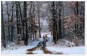
Habitat and Trail info: Stretching for 20 miles along Cumberland Mountain and ranging from 1 to 4 miles in width, the park contains 20,500 acres of which 14,000 acres is proposed wilderness. The natural beauty of Appalachian mountain country, lush with vegetation, supports diverse animal life. The majority of the forest is second and third growth Eastern hardwood and conifer mix, the result of timbering and farming over a 175 year period. There are 24 known entries to limestone caves, the best known of which is Gap Cave. Other significant natural features include the Pinnacle, Sand Cave, Devils Garden, and White Rocks. The park contains more than 70 miles of foot and horse trails and five backcountry camping areas.
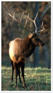
Wildlife Viewing Opportunities: The Park has documentation for 33 mammals, 89 birds, 29 amphibians, 15 reptiles, 27 fish, and 178 insects. Animals that a visitor could expect to see include cottontail rabbit, gray squirrel, opossum, striped skunk, bobcat, white-tailed deer, raccoon, gray fox, black bear, various bats, song birds, (especially migrant and nesting warblers in spring and summer), wild turkey, hawks and vultures, snakes, turtles, and, perhaps, an elk. Migrant warblers in spring and fall. Nesting warblers in spring and summer. The autumn hawk migration is usually spectacular and can be observed from numerous vantage points along the Ridge Trail and especially from the Pinnacle overlook. Cave tours in Gap Cave include sightings of several bat species.