Cultural Resources GIS supplied a mapping team to assist a National Park Service Boundary Adjustment Study.
Report: David W. Lowe Field Work: David Lowe & Gerald Palushock
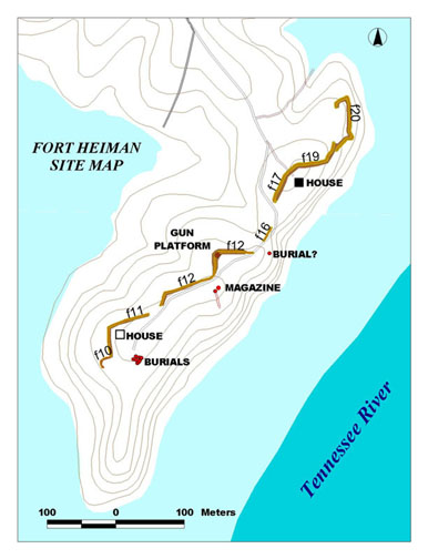
The Fort Heiman complex consists of two principal areas of interest—Fort Heiman proper and what has been called the "Outer Battery" or "Federal Fort." Fort Heiman lies at the end of Fort Heiman road and extends along the high ground of a peninsula that juts into Kentucky Lake. The strategic importance of this location was its proximity to the old channel of the Tennessee River (within 200 meters). From these bluffs, artillery could bring a plunging fire against passing ships in support of Fort Henry, which was on the east bank of the river.
The earthworks are readily visible and largely intact. In this area, the survey crew mapped 593 meters (648 yards) of surviving military earthworks.
The artillery piece placed here would have commanded the road and had direct fire up the ravine northwest to cover the front of the Federal Fort. The ditch behind segments F17 and F19 is wide enough to have served as a covered way for wagons and exits the works between segments F19 and F20. All segments face inland except F20, the northernmost, which faces the river. This segment is probably the oldest of the complex, and may well represent a surviving portion of the original Confederate fort. Because it descends the bluff at a steep incline, it has suffered severe erosion in places.
A shallow shelf along the bluff in rear of the north house may be evidence of Federal destruction of the earthworks when troops abandoned the area in 1863. This shelf appears to have been the bottom of an interior ditch, the parapet having been shoveled down the bluff. The remaining earthworks were likely improved or built by the Federal occupation force in 1862-1863. At the south end of the site, nine pits were mapped which are said to be graves from which the bodies were later removed. Each pit was six feet long; two were nine feet wide, two five feet wide, the rest wide enough for a single burial.
This probably represents the reinterment of fifteen bodies. Farther north, in rear of segment F16, is another pit similar to a single burial. Between these gravesites is a large rectangular hole thought to be the remains of the fort’s magazine. Adjacent is a smaller hole with a communication trench leading down the bluff toward the water. The area is strewn with old firebricks suggesting that the magazine may have had a brick lining that was afterwards scavenged for reuse. Taken together, these resources represent an intact fortification site, a critical part of the Fort Henry complex that would likely provide considerable archeological information.